Product Description
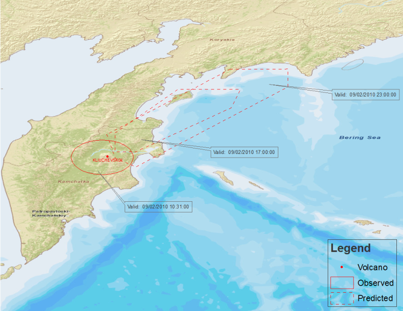
Abstract: This polygon shapefile represents potential areas of ash generated by active volcanoes around the world. It is produced from bulletins create by regional Volcanic Ash Advisory Centers (VAAC) and updated by DTN once each hour.
Purpose: This shapefile can be used to plan flight routes and manage aircraft around volcano threats.
Description: This polygon shapefile identifies potential areas of volcanic ash that could threaten aviation assets. Volcano location is included in attributes, along with text of the VAAC bulletin, and several other attributes.
Product Specification
Shapefile Name: VAAA??yymmddhh
Fields. Features in this product have the following attributes:
| Name | Type | Format | Description |
|---|---|---|---|
|
RecordID |
Number (10) |
n/a |
Record identifier |
|
TotalPoint |
Number (10) |
n/a |
Number of vertices used to create area |
|
StationID |
String (9) |
n/a |
VAAC station identifer |
|
ValidTime |
String (20) |
mm/dd/yyyy hh:mm:ss |
Valid date and time of volcanic ash area |
|
IssueTime |
String (20) |
mm/dd/yyyy hh:mm:ss |
Date and time advisory issued by VAAC |
|
VAAC |
String (25) |
n/a |
Name of Volcanic Ash Advisory Center that issued advisory |
|
VolcanoNam |
String (50) |
n/a |
Name of volcano producing area of ash |
|
VolcanoNum |
String (10) |
n/a |
Identifier of volcano producing area of ash |
|
PolygonNum |
Number (10) |
n/a |
Unique identifer of area (for DTN use) |
|
PointNum |
Number (3) |
n/a |
One of vertices used to create area |
|
Latitude |
Number (18) |
decimal degrees |
Latitude of PointNum |
|
Longitude |
Number (18) |
decimal degrees |
Longitude of PointNum |
|
VolcanoLat |
Number (18) |
decimal degrees |
Latitude of volcano |
|
VolcanoLon |
Number (18) |
decimal degrees |
Longitude of volcano |
|
AreaName |
String (50) |
n/a |
General location of volcano |
|
SummitElev |
Number (9) |
meters |
Elevation of volcano’s peak |
|
AdvisoryNu |
String (15) |
n/a |
VAAC advisory number |
|
InfoSource |
String (150) |
n/a |
Source used to issue resulting advisory |
|
AviationCo |
String (15) |
n/a |
Color code of area for aviation charts |
|
IsObserved |
Number (3) |
n/a |
Determines whether advisory is for observed (1) or predicted (0) ash area |
|
BottomElev |
Number (10) |
ft MSL |
Lowest elevation of ash observed or expected in area (0 is surface) |
|
TopElev |
Number (10) |
ft MSL |
Highest elevation of ash observed or expected in area (0 is unknown) |
|
Remark1 |
String (220) |
n/a |
Miscellaneous remarks |
|
Remark2 |
String (220) |
n/a |
Miscellaneous remarks |
|
Remark3 |
String (220) |
n/a |
Miscellaneous remarks |
|
MoveDirect |
String (15) |
degrees |
Direction of area movement, if known |
|
MoveSpeed |
Number (10) |
kts |
Speed of area movement, if known |
|
Region |
Number (10) |
n/a |
Region identifer, if known |
|
SubRegion |
Number (10) |
n/a |
Sub-region identifer, if known |
|
ErptDet1 |
String (220) |
n/a |
Text from VAAC bulletin |
|
ErptDet2 |
String (220) |
n/a |
Text from VAAC bulletin |
|
ErptDet3 |
String (220) |
n/a |
Text from VAAC bulletin |
|
ErptDet4 |
String (220) |
n/a |
Text from VAAC bulletin |
|
ErptDet5 |
String (220) |
n/a |
Text from VAAC bulletin |
|
ErptDet6 |
String (220) |
n/a |
Text from VAAC bulletin |
|
ErptDet7 |
String (220) |
n/a |
Text from VAAC bulletin |
|
ErptDet8 |
String (220) |
n/a |
Text from VAAC bulletin |
|
ErptDet9 |
String (220) |
n/a |
Text from VAAC bulletin |
|
ErptDet10 |
String (220) |
n/a |
Text from VAAC bulletin |
|
ErptDet11 |
String (220) |
n/a |
Text from VAAC bulletin |
|
ErptDet12 |
String (220) |
n/a |
Text from VAAC bulletin |
|
ErptDet13 |
String (220) |
n/a |
Text from VAAC bulletin |
|
ErptDet14 |
String (220) |
n/a |
Text from VAAC bulletin |
|
ErptDet15 |
String (220) |
n/a |
Text from VAAC bulletin |
|
ErptDet16 |
String (220) |
n/a |
Text from VAAC bulletin |
|
ErptDet17 |
String (220) |
n/a |
Text from VAAC bulletin |
|
ErptDet18 |
String (220) |
n/a |
Text from VAAC bulletin |
|
ErptDet19 |
String (220) |
n/a |
Text from VAAC bulletin |
|
ErptDet20 |
String (220) |
n/a |
Text from VAAC bulletin |
GeoDatabase Specification
Spatial Table Name: VAAA
Views. The following spatial views are available on this spatial table:
| Microsoft SQL Server | Oracle |
|---|---|
|
VAAA_View CrntVolAshAdv_View FcstVolAshAdvNow_View FcstVolAshAdvNowPlus06_View FcstVolAshAdvNowPlus12_View |
VAAA_View CrntVolAshAdv_View FcstVolAshAdvNow_View FcstVolAshAdvNowPlus06_View FcstVolAshAdvNowPlus12_View |
Columns. Features in this spatial table have the following attributes:
| Name | ArcSDE Data Type |
|---|---|
|
RecordID |
Integer |
|
TotalPoint |
Integer |
|
StationID |
String(9) |
|
ValidTime |
String(20) |
|
IssueTime |
String(20) |
|
VAAC |
String(25) |
|
VolcanoName |
String(50) |
|
VolcanoNum |
String(10) |
|
PolygonNum |
Integer |
|
PointNum |
Integer |
|
Latitude |
Double |
|
Longitude |
Double |
|
VolcanoLat |
Double |
|
VolcanoLon |
Double |
|
AreaName |
String(50) |
|
SummitElev |
Double |
|
AdvisoryNum |
String(15) |
|
InfoSource |
String(150) |
|
AviationCo |
String(15) |
|
IsObserved |
Integer |
|
BottomElev |
Integer |
|
TopElev |
Integer |
|
Remark1 |
String(220) |
|
Remark2 |
String(220) |
|
Remark3 |
String(220) |
|
MoveDirect |
String(15) |
|
MoveSpeed |
Integer |
|
Region |
Integer |
|
SubRegion |
Integer |
|
ErptDet1 |
String(220) |
|
ErptDet2 |
String(220) |
|
ErptDet3 |
String(220) |
|
ErptDet4 |
String(220) |
|
ErptDet5 |
String(220) |
|
ErptDet6 |
String(220) |
|
ErptDet7 |
String(220) |
|
ErptDet8 |
String(220) |
|
ErptDet9 |
String(220) |
|
ErptDet10 |
String(220) |
|
ErptDet11 |
String(220) |
|
ErptDet12 |
String(220) |
|
ErptDet13 |
String(220) |
|
ErptDet14 |
String(220) |
|
ErptDet15 |
String(220) |
|
ErptDet16 |
String(220) |
|
ErptDet17 |
String(220) |
|
ErptDet18 |
String(220) |
|
ErptDet19 |
String(220) |
|
ErptDet20 |
String(220) |