DTN is elated to share the next product in our Flight Hazards Forecast suite to help operators mitigate the risk of turbulence on their fleet, our Rapid Update Turbulence Forecast.
DTN’s Rapid Update Turbulence Forecast is a ‘NOWcast’, tactical forecast tool for users to understand the potential of Convective Turbulence in relation to their assets.
After an aircraft departs, forecast turbulence related to thunderstorms can and likely will change. In order to make proper flight decisions, pilots and dispatchers need to know where these potential turbulent areas will be when the aircraft arrives at a future location.
Beginning today, DTN’s Rapid Update Turbulence Forecast product is available within our AviationSentry portal, Data Delivery Services and Flight Route Alerting API.
Overview:
-
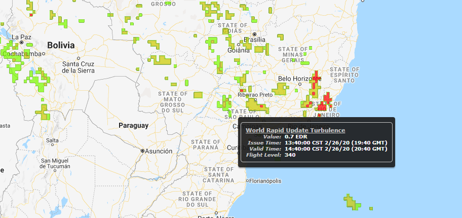
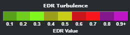
Unit Value: Eddy Dissipation Rate (EDR) from 0.1 to 0.9
-
Forecast Horizon: Next 60 minutes
-
Update rate: Every 10 minutes
-
Altitudes: 29 unique levels
-
Domains: Global and North America
Technical Overview
Because convection often forms in situations which are difficult for numerical weather prediction models to resolve and strong convection is easy to observe, the DTN Rapid Update Turbulence Forecast utilizes observations of convection instead of model forecasts to identify areas of turbulence potential.
Observation of strong convection is easily detected through real-time lightning information. Lightning forms within storms when the turbulent updraft flow separates precipitation of different charges. Therefore, the stronger the updraft, the more frequent these charge separations occur and the more frequent are lightning flashes. Since lightning forms in turbulent updrafts, it is an ideal observation platform to observe updraft locations.
To initiate the forecast process, DTN leverages a blend of world-class lightning networks to create a global lightning density grid every 10 minutes at a 0.1 degree latitude/longitude resolution. The DTN algorithm then computes turbulence potential from updrafts, from downdrafts, and above overshooting tops.
As mentioned, DTN forecasts this grid of turbulence potential to one hour ahead. Each grid point is moved by two different vectors, (1) the advecting vector which represents how individual thunderstorm cells will move, and (2) the propagating vector which represents how the storm body will develop.
Accessing the Rapid Update Turbulence Forecast
AviationSentry
To access the Rapid Update Turbulence Forecast within AviationSentry, after logging in, choose the ‘Weather-Radar/Sat’ option within the navigation menu on the left-hand side of AviationSentry.
Once the layered map has loaded, navigate to the primary toolbar at the top center of the page and mouseover the Layers menu.
After the Layers menu populates, mouseover the ‘Enhanced Flight Hazards’ menu option:
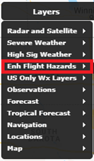
Upon mouseover of the ‘Enhanced Flight Hazards’ menu option, a list of proprietary DTN forecast layers related to Turbulence, Icing, and Thunderstorms will be revealed.
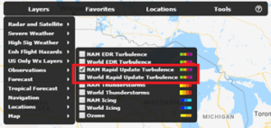
The options are:
-
NAM Rapid Update Turbulence
-
World Rapid Update Turbulence
After selection of a Rapid-Update Turbulence layer, users can adjust the Layer Settings within the menu on the lower right of AviationSentry.
29 different flight levels from 1,000 feet to 53,000 feet are displayed.
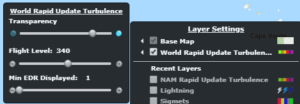
Similar to other DTN Turbulence forecast products, the Rapid-Update Turbulence Forecast depiction is also in Eddy Dissipation Rate (EDR) values from 0.1 to 0.9.
Data – Web Mapping Service
The Rapid Update Turbulence Forecast is also available via DTN’s WeatherSentry API.
Data – Shapefile Format
DTN can provide data delivery of the Rapid Update Convective Turbulence Forecast.
- Shapefile Name:
- fh_(fm)C(I)TB01(md)(hhmm).shp
- Where:
- (fm) = Forecast model (NX – North America and WP – Global)
- (I) = Flight level code (1 character, see code listing below)
- (md) = model run day (GMT – 2 digits)
- (hhmm) = model runtime (GMT – 4 digits)
- Typical file sizes for the bundle are as follows:
- Global Files – 29 zip files with total size of 4.2mb. Individual Zips range from 30-375kb
- North America – 29 zip files with a total size of 630kb. Individual Zips range from 1-55kb
Data – geoJSON format
DTN can provide geoJSON flat-file data delivery of the Rapid Update Convective Turbulence Forecast.
- File Name:
- JH_(fm)C(I)TB01(md)(hhmm)
- Where:
- (fm) = Forecast model (NX – North America and WP – Global)
- (I) = Flight level code (1 character, see code listing below)
- (md) = model run day (GMT – 2 digits)
- (hhmm) = model runtime (GMT – 4 digits)
Flight Route Alerting
To access real-time alerts of convective turbulence potential within DTN’s Flight Route Alerting API, you’ll need to add the new Rapid Update Turbulence Forecast alarm type.
- Alarm Type
- EDRNOWCast
- Property
- EDR
- Example Type
- 0.2
- Value Type
- String-enumeration
- Units/Ranges
- EDR (0.1, 0.2, 0.3, 0.4, 0.5, 0.6, 0.7, 0.8, 0.9)
- Coverage Area
- Global (80N-80S)
For further information, please reference FlightPlanAlertingBriefingAPI.