Product Description
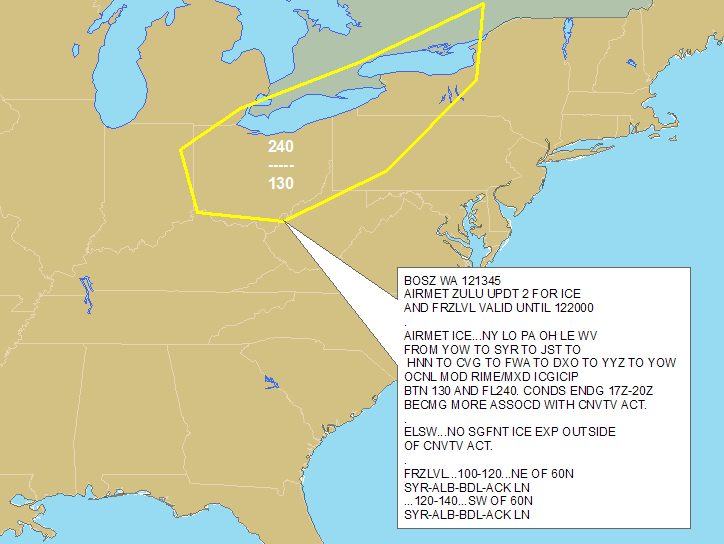
Abstract: This polygon shapefile, which covers the contiguous United States and surrounding waters, identifies areas of potential aircraft icing and icing type and severity based on advisories from the National Weather Service Aviation Weather Center. AIRMET icing shapefiles are updated hourly.
Purpose: This shapefile can be used to plan flight routes and manage aircraft around aircraft icing threats.
Description: Icing AIRMETs identify widespread regions of moderate icing at flight levels or moderately low freezing levels. DTN decodes and geo-references each AIRMET bulletin from the National Weather Service Aviation Weather Center for use in your GIS. Decoded icing information includes severity, flight level heights (base and top), extent, height of freezing level, and valid times. Coverage includes the lower 48 United States and surrounding coastal waters. Use this information to alert flight planners, pilots and operators of all aircraft of regions and airports with potentially dangerous aircraft icing conditions.
Product Specification
Shapefile Name: WPXZyymmddhh
Fields. Features in this product have the following attributes:
| Attribute | Type | Format | Description |
|---|---|---|---|
|
PolygonNum |
Number (10) |
n/a |
Polygon identification number |
|
Latitude |
Number (18) |
decimal degrees |
Recommended location of contour label |
|
Longitude |
Number (18) |
decimal degrees |
Recommended location of contour label |
|
PointNum |
Number (10) |
n/a |
|
|
SevCat |
Number (10) |
n/a |
Coded turbulence severity category (2 = LIGHT, 3 = MODERATE, 4 = SEVERE) |
|
StationID |
String (10) |
n/a |
Issuing aviation weather center service unit |
|
AirmetType |
String (10) |
n/a |
AIRMET type (ZULU) |
|
ValidTime |
String (20) |
mm/dd/yyyy hh:mm:ss |
Start or update time of advisory |
|
ExpireTime |
String (20) |
mm/dd/yyyy hh:mm:ss |
End time of advisory |
|
UpdateNum |
Number (3) |
n/a |
Current update number (number of times bulletin has been updated) |
|
MessageID |
Number (3) |
n/a |
Sequential weather center message identifier |
|
TotalPts |
Number (10) |
n/a |
Total number of polygon vertices |
|
MessageTyp |
String (20) |
n/a |
AIRMET type description (ICE) |
|
Severity |
String (20) |
n/a |
Description of icing severity category (MODERATE, SEVERE) |
|
LayerNum |
Number (3) |
n/a |
Layer number (if total number layers more than one) |
|
TopLevel |
Number (5) |
ft/100 |
Upper boundary of icing (above ground level) |
|
BottomLeve |
Number (10) |
ft/100 |
Lower boundary of icing (above ground level) |
|
TotalLayer |
Number (3) |
n/a |
Total number of layers |
|
IceType |
String (10) |
n/a |
Not used |
|
MsgTxt1 |
String (220) |
n/a |
Message body text |
|
MsgTxt2 |
String (220) |
n/a |
Message body text |
|
MsgTxt3 |
String (220) |
n/a |
Message body text |
|
MsgTxt4 |
String (220) |
n/a |
Message body text |
|
MsgTxt5 |
String (220) |
n/a |
Message body text |
|
MsgTxt6 |
String (220) |
n/a |
Message body text |
|
MsgTxt7 |
String (220) |
n/a |
Message body text |
|
MsgTxt8 |
String (220) |
n/a |
Message body text |
|
BulTxt1 |
String (220) |
n/a |
Other bulletin text |
|
BulTxt2 |
String (220) |
n/a |
Other bulletin text |
|
BulTxt3 |
String (220) |
n/a |
Other bulletin text |
|
BulTxt4 |
String (220) |
n/a |
Other bulletin text |
|
BulTxt5 |
String (220) |
n/a |
Other bulletin text |
|
BulTxt6 |
String (220) |
n/a |
Other bulletin text |
|
BulTxt7 |
String (220) |
n/a |
Other bulletin text |
|
BulTxt8 |
String (220) |
n/a |
Other bulletin text |
GeoDatabase Specification
Spatial Table Name: WPXZ
Views. The following spatial views are available on this spatial table:
| Microsoft SQL Server | Oracle |
|---|---|
|
WPXZ_View FcstAirmetIce_View |
WPXZ_View FcstAirmetIce_View |
Columns. Features in this spatial table have the following attributes:
| Name | ArcSDE Data Type |
|---|---|
|
ValidTime |
String(20) |
|
ExpireTime |
String(20) |
|
PolygonNum |
Integer |
|
Latitude |
Double |
|
Longitude |
Double |
|
PointNum |
Integer |
|
SevCat |
Integer |
|
StationID |
String(10) |
|
AirmetType |
String(10) |
|
UpdateNum |
Integer |
|
MessageID |
Integer |
|
TotalPts |
Integer |
|
MessageTyp |
String(20) |
|
Severity |
String(20) |
|
LayerNum |
Integer |
|
TopLevel |
Integer |
|
BottomLeve |
Integer |
|
TotalLayer |
Integer |
|
IceType |
String(10) |
|
MsgTxt1 |
String(220) |
|
MsgTxt2 |
String(220) |
|
MsgTxt3 |
String(220) |
|
MsgTxt4 |
String(220) |
|
MsgTxt5 |
String(220) |
|
MsgTxt6 |
String(220) |
|
MsgTxt7 |
String(220) |
|
MsgTxt8 |
String(220) |
|
BulTxt1 |
String(220) |
|
BulTxt2 |
String(220) |
|
BulTxt3 |
String(220) |
|
BulTxt4 |
String(220) |
|
BulTxt5 |
String(220) |
|
BulTxt6 |
String(220) |
|
BulTxt7 |
String(220) |
|
BulTxt8 |
String(220) |