Product Description
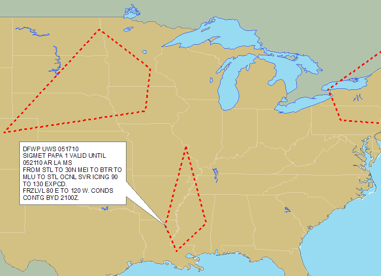
Abstract: This polygon shapefile, which covers the contiguous United States and surrounding waters, identifies widespread areas of potentially hazardous high-level flight weather (other than convective activity), including severe icing, severe or extreme turbulence, reduced visibility from dust storms and sandstorms, and volcanic ash. It is based on advisories from the National Weather Service Aviation Weather Center, and is updated every hour.
Purpose: This shapefile can be used to plan flight routes and manage aircraft around high-level flight weather threats.
Description: DTN decodes and geo-references all SIGMET bulletins from the National Weather Service Aviation Weather Center for use in your GIS. Decoded flight hazard information includes type, height (top), extent and valid times. Coverage includes the lower 48 United States and coastal waters. Use this information to alert flight planners, pilots and operators of all aircraft of regions with potentially hazardous weather conditions. SIGMETs identify widespread regions of potentially hazardous high-level flight weather for all aircraft from other than convective activity, including: Severe icing; Severe or extreme turbulence; Dust storms and sandstorms lowering visibilities to less than three (3) miles; Volcanic ash.
Product Specification
Shapefile Name: WPSGyymmddhh
Fields. Features in this product have the following attributes:
| Name | Type | Format | Description |
|---|---|---|---|
|
PolygonNum |
Number (10) |
n/a |
Polygon identification number |
|
SigmetID |
Number (10) |
n/a |
SIGMET bulletin identification number |
|
PointNum |
Number (10) |
n/a |
Point number |
|
SevCat |
Number (10) |
n/a |
Coded icing and turbulence severity category (3 = MODERATE, 4 = SEVERE) |
|
Latitude |
Number (18) |
decimal degrees |
Recommended location of contour label |
|
Longitude |
Number (18) |
decimal degrees |
Recommended location of contour label |
|
StationID |
String (10) |
n/a |
Issuing aviation weather center service unit |
|
ValidTime |
String (20) |
mm/dd/yyyy hh:mm:ss |
Start or update time of advisory |
|
ExpireTime |
String (20) |
mm/dd/yyyy hh:mm:ss |
End time of advisory |
|
TotalPts |
Number (10) |
n/a |
Total number of polygon vertices |
|
LayerNum |
Number (3) |
n/a |
Layer number (if total number layers more than one) |
|
TopLvl |
Number (5) |
ft/100 |
Upper boundary of hazard (above ground level) |
|
BtmLvl |
Number (5) |
ft/100 |
Lower boundary of hazard (above ground level) |
|
TtlLayers |
Number (3) |
n/a |
Total number of layers |
|
IceType |
String (10) |
n/a |
Not used |
|
ReportType |
String (10) |
n/a |
ICE, TURB, VOLC |
|
RawTxt1 |
String (220) |
n/a |
Bulletin text |
|
RawTxt2 |
String (220) |
n/a |
Bulletin text |
|
RawTxt3 |
String (220) |
n/a |
Bulletin text |
|
RawTxt4 |
String (220) |
n/a |
Bulletin text |
|
RawTxt5 |
String (220) |
n/a |
Bulletin text |
|
RawTxt6 |
String (220) |
n/a |
Bulletin text |
|
RawTxt7 |
String (220) |
n/a |
Bulletin text |
|
RawTxt8 |
String (220) |
n/a |
Bulletin text |
GeoDatabase Specification
Spatial Table Name: WPSG
Views. The following spatial views are available on this spatial table:
| Microsoft SQL Server | Oracle |
|---|---|
|
WPSG_View FcstSIGMET_View |
WPSG_View FcstSIGMET_View |
Columns. Features in this spatial table have the following attributes:
| Name | ArcSDE Data Type |
|---|---|
|
ValidTime |
String(20) |
|
ExpireTime |
String(20) |
|
SigmetID |
Integer |
|
PolygonNum |
Integer |
|
PointNum |
Integer |
|
SevCat |
Integer |
|
Latitude |
Double |
|
Longitude |
Double |
|
StationID |
String(5) |
|
TotalPts |
Integer |
|
LayerNum |
Integer |
|
TopLvl |
Integer |
|
BtmLvl |
Integer |
|
TtlLayers |
Integer |
|
IceType |
String(25) |
|
ReportType |
String(25) |
|
RawTxt1 |
String(220) |
|
RawTxt2 |
String(220) |
|
RawTxt3 |
String(220) |
|
RawTxt4 |
String(220) |
|
RawTxt5 |
String(220) |
|
RawTxt6 |
String(220) |
|
RawTxt7 |
String(220) |
|
RawTxt8 |
String(220) |
Related Pages
Temporary Flight Restrictions Echo Tops International SIGMETs