Product Description
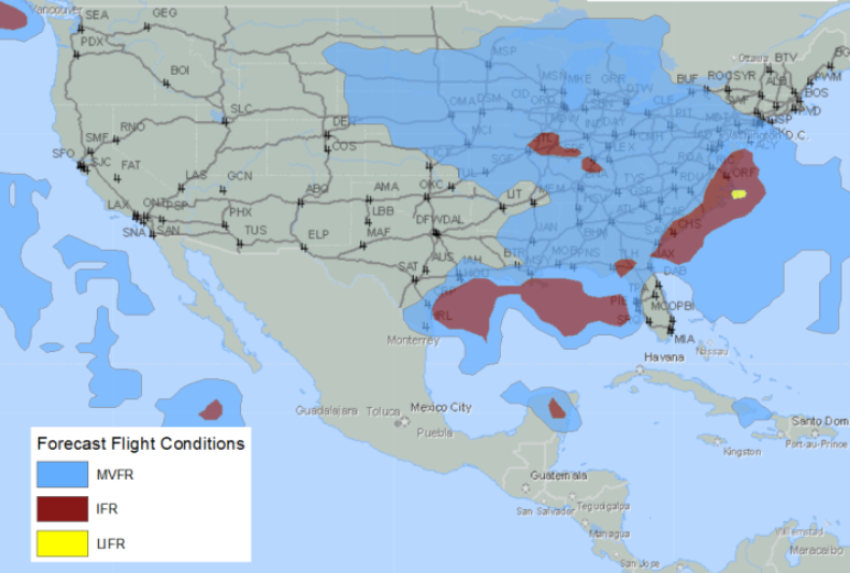
Abstract: These polygon shape files depict the lowest flight rules (the combination of cloud ceilings and surface visibility) forecast during each of the next 1, 2, …, 23 hours. The forecasts are created by DTN meteorologists, and are updated every hour.
Purpose: These shapefiles can be used for flight planning, airport and helicopter operations, and other applications impacted by low clouds and visibilities.
Description: These polygon shape files combine the cloud ceilings (areas where the cloud cover is forecast to be broken or overcast) and surface visibility into a single flight category forecast during each of the next 1, 2, …, 23 hours. The forecasts are created by DTN meteorologists, and are updated every hour. The forecasts cover North America from Southern Canada south to the Gulf of Mexico. The polygons are contoured by flight rule into four aviation categories: (i) Low Instrument Flight Rules (LIFR): Ceiling below 500 feet AGL AND/OR Visibility less than 1 mile, (ii) Instrument Flight Rules (IFR): Ceiling 500 to below 1000 feet AGL AND/OR Visibility 1 mile to less than 3 miles, (iii) Marginal Visual Flight Rules (MVFR) Ceiling 1000 to below 3000 feet AGL AND/OR Visibility 3 mile to less than 5 miles, (iv) Visual Flight Rules (VFR) Ceiling greater than 3000 feet AGL AND Visibility greater than 5 miles. By definition, IFR is ceiling less than 1,000 feet AGL and/or visibility less than 3 miles while LIFR is a sub-category of IFR, and VFR is ceiling greater than or equal to 3,000 feet AGL and visibility greater than or equal to 5 miles while MVFR is a sub-category of VFR.
Product Specification
Shapefile Name: FCON??yymmddhh
Fields. Features in this product have the following attributes:
| Name | Type | Format | Description |
|---|---|---|---|
|
PolygonNum |
Number (3) |
n/a |
Polygon identification number |
|
ValidTime |
String (19) |
mm/dd/yyyy hh:mm:ss |
Model forecast valid time (GMT) |
|
ModelTime |
String (19) |
mm/dd/yyyy hh:mm:ss |
Model run time (GMT) |
|
TotalPts |
Number (4) |
n/a |
Total number of polygon vertices |
|
Latitude |
Number (14) |
decimal degrees |
Recommended location of contour label |
|
Longitude |
Number (14) |
decimal degrees |
Recommended location of contour label |
|
FltCode |
Number (6) |
Flight Code categories; see FltCode table |
|
|
FltDescrip |
String (10) |
n/a |
Flight code description |
GeoDatabase Specification
Spatial Table Name: FCON
Views. The following spatial views are available on this spatial table:
| Microsoft SQL Server | Oracle |
|---|---|
|
FCON_View FcstFCon_View FcstFConNow_View FcstFConNowPlusAll_View FcstFConNowPlus01_View FcstFConNowPlus02_View FcstFConNowPlus03_View |
FCON_View |
Columns. Features in this spatial table have the following attributes:
| Name | ArcSDE Data Type |
|---|---|
|
PolygonNum |
Integer |
|
ValidTime |
String(20) |
|
ModelTime |
String(20) |
|
TotalPts |
Integer |
|
Latitude |
Double |
|
Longitude |
Double |
|
FltCode |
Integer |
|
FltDesc |
String(10) |