Product Description
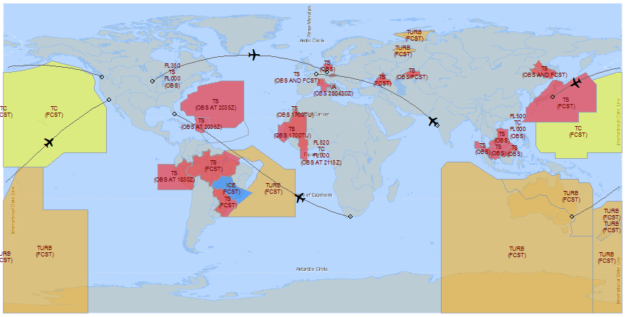
Abstract: This polygon shapefile, which covers the world, identifies areas of potentially hazardous high-level flight weather, including hail, cumulonimbus clouds, thunderstorms, tropical cyclones, moderate or severe turbulence, severe icing, mountain wave turbulence, duststorms, sandstorms and volcanic ash. It is based on advisories international SIGMET advisories, and is updated every 10 minutes.
Purpose: This shapefile can be used to plan flight routes and manage aircraft around transonic and subsonic flight level flight weather threats.
Description: DTN decodes and geo-references international SIGMET bulletins for use in your GIS. Decoded flight hazard information includes type, height (top), extent and valid times. Coverage is worldwide. Use this information to plan flights, alert pilots and operators of all aircraft to avoid regions with potentially hazardous flight weather conditions. SIGMETs identify widespread regions of potentially hazardous high-level flight weather for aircraft, including hail, cumulonimbus clouds, thunderstorms, tropical cyclones, moderate or severe turbulence, severe icing, mountain wave turbulence, duststorms, sandstorms and volcanic ash.
Product Specification
Shapefile Name: SIGMEThhmm
Fields: Features in this product have the following attributes:
| Name | Type | Format | Description |
|---|---|---|---|
| PolygonNum | Number (10) | n/a | Polygon identification number |
| SigmetID | Number () | n/a | SIGMET bulletin identification number |
| PointNum | Number (10) | n/a | Point number |
| SevCat | Number (10) | n/a | Coded icing and turbulence severity category (3 = MODERATE, 4 = SEVERE) |
| Latitude | Number (18) | decimal degrees | Recommended location of contour label |
| Longitude | Number (18) | decimal degrees | Recommended location of contour label |
| StationID | String (10) | n/a | Issuing aviation weather center service unit |
| ValidTime | String (20) | mm/dd/yyyy hh:mm:ss | Start or update time of advisory |
| ExpireTime | String (20) | mm/dd/yyyy hh:mm:ss | End time of advisory |
| TotalPts | Number (10) | n/a | Total number of polygon vertices |
| FIRName | String (100) | n/a | Fllight Information Region |
| SequenceNu | String (10) | n/a | Advisory sequence number |
| Movement | String (50) | n/a | Movement of hazard description (e.g. WNW 10KT) |
| IntensityC | String (25) | n/a | Change in intensity description; INTSF = intensifying, LTL CHNG EXPD = little change expected, NC = no change, WKN = weakening) |
| ObsFcst | String (25) | n/a | Observation or forecast description; FCST, OBS, OBS AND FCST, OBS/FCST. Time of observation may also be appended |
| LayerNum | Number (10) | n/a | Layer number (if total number layers more than one) |
| TopLvl | Number (5) | ft/100 | Upper boundary of hazard (above ground level) |
| BtmLvl | Number (5) | ft/100 | Lower boundary of hazard (above ground level) |
| TtlLayers | Number (3) | n/a | Total number of layers |
| IceType | String (10) | n/a | Not used |
| ReportType | String (10) | n/a | ICE = icing, TC = tropical cyclone, TS = thunderstorm, TURB = turbulence, VA = Volcanic ash |
| RawTxt1 | String (220) | n/a | Bulletin text |
| RawTxt2 | String (220) | n/a | Bulletin text |
| RawTxt3 | String (220) | n/a | Bulletin text |
| RawTxt4 | String (220) | n/a | Bulletin text |
| RawTxt5 | String (220) | n/a | Bulletin text |
| RawTxt6 | String (220) | n/a | Bulletin text |
| RawTxt7 | String (220) | n/a | Bulletin text |
| RawTxt8 | String (220) | n/a | Bulletin text |
| RawTxt9 | String (220) | n/a | Bulletin text |
| RawTxt10 | String (220) | n/a | Bulletin text |
| RawTxt11 | String (220) | n/a | Bulletin text |
| RawTxt12 | String (220) | n/a | Bulletin text |
| RawTxt13 | String (220) | n/a | Bulletin text |
| RawTxt14 | String (220) | n/a | Bulletin text |
| RawTxt15 | String (220) | n/a | Bulletin text |
GeoDatabase Specification
Spatial Table Name: SIGM
Views: The following spatial views are available on this spatial table:
| Microsoft SQL Server | Oracle |
|---|---|
| SIGM_View | SIGM_View |
| CrntIntlSIGMET_View | CrntIntlSIGMET_View |
Columns: Features in this spatial table have the following attributes:
| Name | ArcSDE Data Type |
|---|---|
| PolygonNum | Integer |
| SigmetID | Integer |
| PointNum | Integer |
| SevCat | Integer |
| Latitude | Double |
| Longitude | Double |
| StationID | String(10) |
| ValidTime | String(20) |
| ExpireTime | String(20) |
| TotalPts | Integer |
| FIRName | String(100) |
| SequenceNum | String(10) |
| Movement | String(50) |
| IntensityChg | String(25) |
| ObsFcst | String(25) |
| LayerNum | Integer |
| TopLvl | Integer |
| BtmLvl | Integer |
| TtlLayers | Integer |
| IceType | String(10) |
| ReportType | String(10) |
| RawTxt1 | String(220) |
| RawTxt2 | String(220) |
| RawTxt3 | String(220) |
| RawTxt4 | String(220) |
| RawTxt5 | String(220) |
| RawTxt6 | String(220) |
| RawTxt7 | String(220) |
| RawTxt8 | String(220) |
| RawTxt9 | String(220) |
| RawTxt10 | String(220) |
| RawTxt11 | String(220) |
| RawTxt12 | String(220) |
| RawTxt13 | String(220) |
| RawTxt14 | String(220) |
| RawTxt15 | String(220) |